
Bike Ride of the Month for April: Edgehill
Park at the end of Abbotsford Street in the large parking area just beyond Edgehill School.
A multi-use trail begins right there at the tree line, which may be muddy if it has been raining. After a few hundred meters take the left fork, and then again after a few hundred meters the next left fork. A short climb and you reach a spur. Turn right onto it and follow it for several hundred meters, turn left and follow this main spur with its many water bars.
You are riding through Tla’amin First Nation treaty settlement lands, headed in the direction of Duck Lake FSR Branch 2. This spur leads you upwards for several hundred meters until finally, still dipping through large water bars, you start to descend, still on a wide gravel roadway. Watch for a wide gravel spur turning right and take it.
You are now riding through the Powell River Community Forest. After a few hundred meters you reach Zevier’s trail on your left. This short single-track leads to Blue Trail, an ancient roadway where you turn right and follow it for 2 or 3 kilometers to Blue Connector, another old dirt roadway on your left.
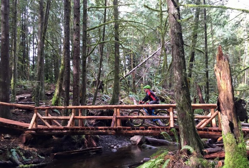
Follow Blue Connector across 2 wide beautifully built wooden bridges(built by the ATV club), and then a tiny wooden plank bridge built by PRCA’s Chain Gang. You are now approaching the beginning of the Game Trail Network, so slow down and watch for a barely visible trail leading off to the left.
Now the fun begins!
You are on “Game On Trail” and will soon reach the “Third Crossing” plank bridging alongside a marshy area where the Chain Gang spotted several red-tailed hawks while building the bridges. Each time you reach single-track intersections, stay left and you will emerge onto Island Timberland’s private property, a clear cut with a great view of the Smith Mountain Range.
Follow this single-track to a spur and turn left, following this gravel spur roadway most of the way across the long cut block to a Y intersection. Take the right arm which is now a dirt ATV track and soon you will see an unmarked trail on your right. If you miss it and enter large mature timber you have missed the turn-off.
Follow this single-track through the remaining clear cut into the timber and look for a well-marked intersection of trails. Straight ahead is the beginning of ”Game Over Trail”. Had you turned right you would have entered the Game Trail which leads directly to Squirrel Crossing on Branch 2 of the FSR. But instead, you are riding straight ahead on ”Game Over” and towards more new plank bridges, and into another Community Forest clear cut.
The trail leads you out onto a rocky spur road. Go down it, stay left, cross the bridge and turn right. This road will lead you towards a landing before it starts to drop down towards Branch 2. At the landing on your left is a trail starting between 2 piles of concrete. You should see trail markers at the treeline of mature forest straight ahead. Follow the trail into the trees and you will be rewarded with still more new plank bridging across a wide mossy drainage area used by a local elk herd. Climb up the other side and you emerge onto Blue Trail not too far from where you were when you left Zevier’s Trail. Turn right. Take Blue Trail all the way to Branch 2.
Cross the road and you will see a marker at the start of Bob’s Yer Uncle Trail, a local favorite. Ride it all the way down towards a 75 metre boardwalk across yet another drainage area and fish stream which we call Cream Soda Creek. You will cross 2 very old dirt roadways and then see a trail on your left with several orange markers. Take this down onto Branch 7 roadway, go right and head towards the concrete barrier but just up on the crest of the hill on your left before you reach the barrier is a new approach to the Cream Soda Trail. Follow it all the way back to Branch 2 after you have crossed the amazing Illusion Bridge on Cream Soda Creek ..yes, that creek again.
Emerging onto the roadway, go left and at the major intersection of Branches 2 & 7, on your right is a concealed trail just beyond a tree with 3 orange markers on it. As you drop into the trail you will see an old 51 Dodge.
If you don’t, you are hopelessly lost.
Follow this trail out onto a spur, turn left, then right onto another spur and you will cross a stream and then a steep but oddly fun challenging climb along this gravel spur to a landing. Look for the trail on your left. Follow it into the mature timber and the intersection of Myrtle Springs Trail.
Turn right and climb, then descend and cross a long wooden bridge. An old dirt roadway along the edge of the treeline leads you to an intersection, where you turn left and drop down onto the same Edgehill Main gravel spur that you rode as you headed out. Turn left onto it and almost immediately turn right onto a grassy old roadway that becomes fun singletrack at the bottom of the hill. This long stretch of recently brushed out trail is called the ”Bucket Trail” a favourite amongst local riders – quick and dirty little secret that it is! This leads you out onto a gravel spur. Turn right and you soon reach the same spur that took you right as you headed out. Now take it left and head back to the parking lot.
Yes, there are other ways back but I need a drink and so do you.
credit: Wayne Brewer
